|
||||
|
||||
|
Ancient Era
Maps: 1300 BC to 499 AD
Map location:
http://www.WorldHistoryMaps.info/images/East-Hem_1300bc.jpg
Updated:
Primary Sources for
East-Hem_1300bc.jpg:
1. The DK Atlas of World History, 2000
edition. Map of The
World, 2500-1250
I -
African information:
* African Tribal locations are derived from:
1. The DK Atlas of World History. Map of Development of Complex Societies in
Africa. Pg 160.
(Bantus, Berber Tribes, Chadians, Cushites, Daamat, Garamantes, Gur, Khoisanss, Kwa, Libyans,
Mandes,
II -
Asian information:
* Greater
India (Including modern Bangladesh, India, and
Pakistan):
Map location:
http://www.WorldHistoryMaps.info/images/East-Hem_1000bc.jpg
Updated:
Primary Sources for
East-Hem_1000bc.jpg:
1. The DK Atlas of World History, 2000
edition. Map of The
World, 1250-750
2. User:Briangotts. Map of the World_1000_BCE.png. Available on Wikipedia.
I -
African information:
* African Tribal locations are derived from:
1. The DK Atlas of World History. Map of The Development of Complex Societies in
Africa. (Pg 160).
(Bantus, Berber Tribes,
Chadians, Cushites, Daamat, Garamantes, Gur, Khoisan Peoples, Kwa, Libyans,
Mandes,
Nilotic Peoples, West
Atlantic Peoples, etc.)
II -
Asian information:
* Chinese (Zhou Dynasty) information:
1. Albert Herrmann, Ph.D. History & Commercial Atlas of China. Map of The
Chou Dynasty, 11th-9th Centuries BC.
* Greater
India (Including modern Bangladesh, India, and
Pakistan):
Map location:
(Not currently available)
Map location:
http://www.WorldHistoryMaps.info/images/East-Hem_625bc.jpg
Updated:
Primary Sources for
East-Hem_625bc.jpg:
1. The DK Atlas of World History, 2000
edition. (See specific references below)
I -
African information:
* African Tribal locations are derived from:
1. The DK Atlas of World History. Map of The Development of Complex Societies in
Africa. (Pg 160).
(Bantus, Berbers,
Chadians, Cushites, Daamat, Garamantes, Gur, Khoisans, Kwa, Libyans,
Mandes,
Nilotic Peoples, West Atlantic Peoples,
etc.)
II -
Asian information:
* Greater
India (Including modern Bangladesh, India, and
Pakistan):
Map location:
http://www.WorldHistoryMaps.info/images/East-Hem_600bc.jpg
Updated:
Primary Sources for
East-Hem_600bc.jpg:
1. The DK Atlas of World History, 2000
edition. (See specific references below)
I -
African information:
* African Tribal locations are derived from:
1. The DK Atlas of World History. Map of The Development of Complex Societies in
Africa. (Pg 160).
(Bantus, Berbers,
Chadians, Cushites, Daamat, Garamantes, Gur, Khoisans, Kwa, Libyans,
Mandes,
Nilotic Peoples, West Atlantic Peoples,
etc.)
II -
Asian information:
* Greater
India (Including modern Bangladesh, India, and
Pakistan):
Map location:
http://www.WorldHistoryMaps.info/images/images/East-Hem_550bc.jpg
Updated:
Primary Sources for
East-Hem_550bc.jpg:
1. The DK Atlas of World History, 2000
ed. Map of The
World in 500
2. The New Penguin
Atlas of Ancient History, 2002 edition. Map of “The Near East
in 560
3. User:Briangotts. Map of the World_500_BCE.png. Available on Wikipedia.
I -
African information:
* African Tribal locations are derived from:
1. The DK Atlas of World History. Map of The Development of Complex Societies in
Africa. Pg 160.
(Bantus, Berbers,
Chadians, Cushites, Daamat, Garamantes, Gur, Khoisans, Kwa, Libyans,
Mandes,
Nilotic Peoples, West Atlantic Peoples,
etc.)
2. User:Briangotts. Map of the World_500_BCE.png. Available on Wikipedia.
* Carthage borders are derived from:
1. The DK Atlas of World History. Map of The Berber states and the Roman
Empire. Pg. 161
(Shows Carthage
borders in 500
*
1.
The DK Atlas of World History. Map of The Achaemenid Empire c. 550-331
II -
Asian information:
Note: Much of my Asian peoples and tribal locations
are derived from:
1.
The DK Atlas of World History. Map of The World in 500
(Ainu, Dravidians,
Finno-Ugrians, Korean Peoples, Malay Peoples, Mon-Khmer Peoples,
Palaeosiberians,
Papuans, Saba,
Samoyed Peoples, Scythian Tribes, Tochari/Yuezhi, Tungus)
2. User:Briangotts. Map of the World_500_BCE.png. Available on Wikipedia.
(Ainu, Final Jomon
Culture, Korean Peoples, Massagetae, Sakae)
* East Asian (
1.
The DK Atlas of World History. Map of Zhou
2.
Albert Herrmann, Ph.D. History
& Commercial Atlas of China. Map of
Chun-ch'iu Period, 722-482 BC.
* Korean & Manchurian information:
1.
Park
Hyeon. Map of History_of_Korea_500_BC.png. Available on Wikipedia.
* Gerrha borders are derived from:
1. Wikipedia.
Article about Gerrha.
* Greater
India (Including modern Bangladesh, India, and
Pakistan):
1. The DK Atlas of World History. Map of The World in 500
2. User:Briangotts. Map of the World_500_BCE.png. Available on Wikipedia.
3. Wikipedia.
Map of Epic
India.
4. Pennsylvania University. Map of Republics
& Kingdoms of Northern India, c. 600 BCE.
* Iranian Info (Median Empire and Persians):
1.
The DK Atlas of World History. Map of The Achaemenid Empire c. 550-331
2.
Livius.org. Map of Persia in 490 BCE and article about the Achaemenians.
* Văn Lang borders are derived from:
1. User:Briangotts. Map
of Van
Lang. Available on Wikipedia.
2. Wikipedia. Articles about Văn Lang and the Hồng Bàng Dynasty.
Note: Much of my European peoples and tribal
locations are derived from:
1.
The DK Atlas of World History. Map of The World in 500
(Baltic Peoples,
Finno-Ugrians, Illyrians, Samoyed Peoples, Scythians, Thracians)
2. John Haywood. Atlas
of the Celtic World. London Thames & Hudson Ltd., 2001; Pgs.30-37.
3. User:Dbachmann. Maps of Hallstatt_LaTene
800-500 BCE and Hallstatt_culture.png. Available on Wikipedia.
* Brythonic Celts derive from:
1. Wikipedia. Article
about the Brythons.
* Gaelic Celts and Priteni (aka Cruithne, Dál nAraidi, and
Robogdii) derive from:
1. Ireland's
History in Maps. Map of Iron-Age
Ireland.
2. Wikipedia. Articles about the Early History of
Ireland, the Cruithne People, and
Dál nAraidi.
* Gaulic Veneti are described in
1. User:Dbachmann. Map of Hallstatt_LaTene
800-500 BCE.
2. Wikipedia. Article
about the Veneti (Gaul).
* Greek City-States & Colonies are derived from:
1. The DK Atlas of World
History. Section on The Mediterranean
World, 700-300
(Section includes 2 maps of Greek mainland and colonies during this
era.)
2. Wikipedia. Maps
of Greek
Colonies in Antiquity and Greek &
Phoenician Colonies, c. 550 BCE.
* Hallstatt Culture derives from:
1. User:Dbachmann. Map of Hallstatt_LaTene
800-500 BCE.
2. Wikipedia. Article
about the Hallstatt Culture.
* Iberian Peoples derive from:
1. Wikipedia. Map of Ethnographic
Iberia 200 BCE.
2.
Wikipedia. Articles about the Iberians and Pre-Roman
peoples of the Iberian Peninsula.
(Cantabri, Celtiberians, Iberians, Lusitani, Tartessians, Vasconi, etc.)
* Italian Peoples information:
1. The DK Atlas of World
History. Map of The Peoples of Italy in
500
2. User:Dbachmann. Map of Iron Age
Italy. Available on Wikipedia.
3.
Wikipedia. Articles about the peoples listed in the
map. (Bruttii, Etruscans, Ligures,
Roman Republic, Umbrians, etc.)
* Thracian Tribes information:
1. Ancient Thrace and
Thracology. Section on Thracian History.
2. Wikipedia. Articles about the Thracians and Thraco-Cimmerians.
Note: Much of the information in this map was cross-checked with Bruce Gordon's Regnal
Chronologies.
Map location:
http://www.WorldHistoryMaps.info/images/East-Hem_527bc.jpg
Updated:
Primary Sources for
East-Hem_527bc.jpg:
1. The DK Atlas of World History. 2000
edition. Map of The
World in 500
2. The New Penguin
Atlas of Ancient History, 2002 edition. Map of “The Near East
in 515
3. User:Briangotts. Map of the World_500_BCE.png. Available on Wikipedia.
I -
African information:
* African Tribal locations are derived from:
1. The DK Atlas of World History. Map of The Development of Complex Societies in
Africa. Pg 160.
(Bantus, Berbers,
Chadians, Cushites, Daamat, Garamantes, Gur, Khoisans, Kwa, Libyans,
Mandes,
Nilotic Peoples, West Atlantic Peoples,
etc.)
2. User:Briangotts. Map of the World_500_BCE.png. Available on Wikipedia.
* Carthage borders are derived from:
1. The DK Atlas of World History. Map of The Berbers & the Roman
Empire. Pg 161.
* Persian
1.
The DK Atlas of World History. Map of The Achaemenid Empire c. 550-331
II -
Asian information:
Note: Much of my Asian peoples and tribal locations
are derived from:
1.
The DK Atlas of World History. Map of The World in 500
(Ainu, Dravidians,
Finno-Ugrians, Korean Peoples, Malay Peoples, Mon-Khmer Peoples, Palaeosiberians,
Papuans, Saba,
Samoyed Peoples, Scythian Tribes, Tochari/Yuezhi, Tungus)
2. User:Briangotts. Map of the World_500_BCE.png. Available on Wikipedia.
(Ainu, Final Jomon
Culture, Korean Peoples, Massagetae, Sakae)
* East Asian (
1.
The DK Atlas of World History. Map of Zhou
2.
Albert Herrmann, Ph.D. History
& Commercial Atlas of China. Map of
Chun-ch'iu Period, 722-482 BC.
* Korean & Manchurian information:
1.
Park
Hyeon. Map of History_of_Korea_500_BC.png. Available on Wikipedia.
* Gerrha borders are derived from:
1.
Wikipedia. Article about Gerrha.
* Greater
India (Including modern Bangladesh, India, and
Pakistan):
1. The DK Atlas of World History. Map of The World in 500
2. User:Briangotts. Map of the World_500_BCE.png. Available on Wikipedia.
3. Wikipedia. Map of Epic
India.
4. Pennsylvania University. Map of Republics
& Kingdoms of Northern India, c. 600 BCE.
*
1.
The DK Atlas of World History. Map of The Achaemenid Empire c. 550-331
2.
Livius.org. Map of Persia in 490 BCE and article about the Achaemenians.
* Văn Lang borders are derived from:
1. User:Briangotts. Map
of Van
Lang. Available on Wikipedia.
2. Wikipedia. Articles about Văn Lang and the Hồng Bàng Dynasty.
Note: Much of my European peoples and tribal
locations are derived from:
1.
The DK Atlas of World History. Map of The World in 500
(Baltic Peoples,
Finno-Ugrians, Illyrians, Samoyed Peoples, Scythians, Thracians)
2. John Haywood. Atlas
of the Celtic World. London Thames & Hudson Ltd., 2001; Pgs.30-37.
3. User:Dbachmann. Maps of Hallstatt_LaTene
800-500 BCE and Hallstatt_culture.png. Available on Wikipedia.
* Brythonic Celts derive from:
1. Wikipedia. Article
about the Brythons.
* Gaelic Celts and Priteni (aka Cruithne, Dál nAraidi, and
Robogdii) derive from:
1. Ireland's
History in Maps. Map of Iron-Age
Ireland.
2. Wikipedia. Articles about the Early History of
Ireland, the Cruithne People, and
Dál nAraidi.
* Gaulic Veneti are described in
1. User:Dbachmann. Map of Hallstatt_LaTene
800-500 BCE.
2. Wikipedia. Article
about the Veneti (Gaul).
* Greek City-States & Colonies are derived from:
1. The DK Atlas of World
History. Section on The Mediterranean
World, 700-300
(Section includes 2 maps of Greek mainland and colonies during this
era.)
2. Wikipedia. Maps
of Greek
Colonies in Antiquity and Greek &
Phoenician Colonies, c. 550 BCE.
* Hallstatt Culture derives from:
1. User:Dbachmann. Map of Hallstatt_LaTene
800-500 BCE.
2. Wikipedia. Article
about the Hallstatt Culture.
* Iberian Peoples derive from:
1. Wikipedia. Map of Ethnographic
Iberia 200 BCE.
2.
Wikipedia. Articles about the Iberians and Pre-Roman
peoples of the Iberian Peninsula.
(Cantabri, Celtiberians, Iberians, Lusitani, Tartessians, Vasconi, etc.)
* Italian Peoples information:
1. The DK Atlas of World
History. Map of The Peoples of Italy in
500
2. User:Dbachmann. Map of Iron Age
Italy. Available on Wikipedia.
3.
Wikipedia. Articles about the peoples listed in the
map. (Bruttii, Etruscans, Ligures,
Roman Republic, Umbrians, etc.)
* Thracian Tribes information:
1. Ancient Thrace and
Thracology. Section on Thracian History.
2. Wikipedia. Articles about the Thracians and Thraco-Cimmerians.
Note: Much of the information in this map was cross-checked with Bruce Gordon's Regnal
Chronologies.
Map location:
http://www.WorldHistoryMaps.info/images/East-Hem_500bc.jpg
Updated:
Primary Sources for
East-Hem_500bc.jpg:
1. The DK Atlas of World History, 2000
edition. Map of The
World in 500
2. John Nelson. Interactive Historical Atlas of the
World since 500BCE. Map of the "Countries of the World 1/1/500
BCE."
World History Maps
Inc., Alexandria, VA, 2008. Available at www.WorldHistoryMaps.com.
3. The New Penguin
Atlas of Ancient History, 2002 edition. Map of “The Near East
in 515
I -
African information:
* African Tribal locations are derived from:
1. The DK Atlas of World History. Map of The Development of Complex Societies in
Africa. Pg 160.
(Bantus, Berber Tribes,
Chadians, Cushites, Daamat, Garamantes, Gur, Khoisan Peoples, Kwa, Libyans,
Mandes,
Nilotic Peoples, West
Atlantic Peoples, etc.)
2. User:Briangotts. Map of the World_500_BCE.png. Available on Wikipedia.
* Carthage borders are derived from:
1. The DK Atlas of World History. Map of The Berber states and the Roman
Empire. Pg. 161
(Shows Carthage
borders in 500
* Persian
1.
The DK Atlas of World History. Map of The Achaemenid Empire c. 550-331
II -
Asian information:
Note: Much of my Asian peoples and tribal locations
are derived from:
1.
The DK Atlas of World History. Map of The World in 500
(Ainu, Dravidians,
Finno-Ugrians, Korean Peoples, Malay Peoples, Mon-Khmer Peoples,
Palaeosiberians,
Papuans, Saba,
Samoyed Peoples, Scythian Tribes, Tochari/Yuezhi, Tungus)
2. User:Briangotts. Map of the World_500_BCE.png. Available on Wikipedia.
(Ainu, Final Jomon Culture, Korean
Peoples, Massagetae, Sakae)
* East Asian (
1.
The DK Atlas of World History. Map of Zhou
2.
Albert Herrmann, Ph.D. History
& Commercial Atlas of China. Map of
Chun-ch'iu Period, 722-482 BC.
* Korean & Manchurian information:
1.
Park
Hyeon. Map of History_of_Korea_500_BC.png. Available on Wikipedia.
* Gerrha borders are derived from:
1.
Wikipedia. Article about Gerrha.
* Greater
India (Including modern Bangladesh, India, and
Pakistan):
1. The DK Atlas of World History. Map of The World in 500
2. User:Briangotts. Map of the World_500_BCE.png. Available on Wikipedia.
3. Wikipedia.
Map of Epic
India.
4. Pennsylvania University. Map of Republics
& Kingdoms of Northern India, c. 600 BCE.
*
1.
The DK Atlas of World History. Map of The Achaemenid Empire c. 550-331
2.
Livius.org. Map of Persia in 490 BCE and article about the Achaemenians.
* Văn Lang borders are derived from:
1. User:Briangotts. Map
of Van
Lang. Available on Wikipedia.
2. Wikipedia. Articles about Văn Lang and the Hồng Bàng Dynasty.
Note: Much of my European peoples and tribal
locations are derived from:
1.
The DK Atlas of World History. Map of The World in 500
(Baltic Peoples,
Finno-Ugrians, Illyrians, Samoyed Peoples, Scythians, Thracians)
2.
John Haywood. Atlas
of the Celtic World. London Thames & Hudson Ltd., 2001; Pgs.30-37.
3. User:Dbachmann. Maps of Hallstatt_LaTene
800-500 BCE and Hallstatt_culture.png. Available on Wikipedia.
* Brythonic Celts derive from:
1. Wikipedia. Article
about the Brythons.
* Gaelic Celts and Priteni (aka Cruithne, Dál nAraidi, and
Robogdii) derive from:
1. Ireland's
History in Maps. Map of Iron-Age
Ireland.
2. Wikipedia. Articles about the Early History of
Ireland, the Cruithne People, and
Dál nAraidi.
* Gaulic Veneti are described in
1. User:Dbachmann. Map of Hallstatt_LaTene
800-500 BCE.
2. Wikipedia. Article
about the Veneti (Gaul).
* Greek City-States & Colonies are derived from:
1. The DK Atlas of World
History. Section on The Mediterranean
World, 700-300
(Section includes 2 maps of Greek mainland and colonies during this
era.)
2. Wikipedia. Maps
of Greek
Colonies in Antiquity and Greek &
Phoenician Colonies, c. 550 BCE.
* Hallstatt Culture derives from:
1. User:Dbachmann. Map of Hallstatt_LaTene
800-500 BCE.
2. Wikipedia. Article
about the Hallstatt Culture.
* Iberian Peoples derive from:
1. Wikipedia. Map of Ethnographic
Iberia 200 BCE.
2.
Wikipedia. Articles about the Iberians and Pre-Roman
peoples of the Iberian Peninsula.
(Cantabri, Celtiberians, Iberians, Lusitani, Tartessians, Vasconi, etc.)
* Italian Peoples information:
1. The DK Atlas of World
History. Map of The Peoples of Italy in
500
2. User:Dbachmann. Map of Iron Age
Italy. Available on Wikipedia.
3. Wikipedia.
Articles about the peoples listed in the map. (Bruttii, Etruscans, Ligures, Roman Republic, Umbrians,
etc.)
* Thracian Tribes information:
1. Ancient Thrace and
Thracology. Section on Thracian History.
2. Wikipedia. Articles about the Thracians and Thraco-Cimmerians.
Note: Much of the information in this map was cross-checked with Bruce Gordon's Regnal
Chronologies.
Map location:
http://www.WorldHistoryMaps.info/images/East-Hem_400bc.jpg
Updated:
Primary Sources for
East-Hem_400bc.jpg:
1. The DK Atlas of World History, 2000
edition. (See specific references below)
2. John Nelson. Interactive Historical Atlas of the
World since 500BCE. Map of the "Countries of the World 1/1/400
BCE."
World History Maps
Inc., Alexandria, VA, 2008. Available at www.WorldHistoryMaps.com.
3. The New Penguin
Atlas of Ancient History, 2002 edition. Map of “The Near East
in 415
4. User:Briangotts. Map of the World_Map_400_BCE.PNG. Available on Wikipedia.
I -
African information:
* African Tribal locations are derived from:
1. The DK Atlas of World History. Map of The Development of Complex Societies in Africa. Pg 160.
(Bantus, Berber Tribes,
Chadians, Cushites, Daamat, Garamantes, Gur, Khoisan Peoples, Kwa, Libyans,
Mandes,
Nilotic Peoples, West
Atlantic Peoples, etc.)
II -
Asian information:
* Greater India (Including modern Bangladesh, India, and Pakistan):
1. The DK Atlas of
World History. Map of “The Nanda and
Mauryan Empires, 365-181
2. Joseph Schwartzberg. The Historical Atlas of South Asia. Map of "The Achaemenid Empire and the Magadhan Empire".
Note: Much of my European peoples and tribal
locations are derived from:
1.
The DK Atlas of World History. Map of The World in 500
(Baltic Peoples,
Finno-Ugrians, Illyrians, Samoyed Peoples, Scythians, Thracians)
2. John Haywood. Atlas
of the Celtic World. London Thames & Hudson Ltd., 2001; Pgs.30-37.
3.
User:Briangotts. Map of the World_Map_400_BCE.PNG. Available on Wikipedia.
Note: Much of the information in this map was cross-checked with Bruce Gordon's Regnal
Chronologies.
Map location: http://www.WorldHistoryMaps.info/images/East-Hem_350bc.jpg
Updated: 7-15-2009
Primary Sources for
East-Hem_350bc.jpg:
1. The DK Atlas of World History, 2000
edition. (See specific references below)
2. John Nelson. Interactive Historical Atlas of the
World since 500BCE. Map of the "Countries of the World 1/1/350
BCE."
World History Maps
Inc., Alexandria, VA, 2008. Available at www.WorldHistoryMaps.com.
I -
African information:
* African Tribal locations are derived from:
1. The DK Atlas of World History. Map of “The Development of Complex Societies in Africa”. Pg 160.
(Bantus, Berber Tribes,
Chadians, Cushites, Daamat, Garamantes, Gur, Khoisan Peoples, Kwa, Libyans,
Mandes,
Nilotic Peoples, West
Atlantic Peoples, etc.)
II -
Asian information:
* East Asian (Chinese area) information is from:
1. The DK Atlas of World History. Map
of
2. Albert Herrmann, Ph.D. History
& Commercial Atlas of China. Map of “The Contending States Boundries c. 350 BC”.
* Greater India (Including modern Bangladesh, India, and Pakistan):
1. The DK Atlas of
World History. Map of “The Nanda and
Mauryan Empires, 365-181
2. Joseph Schwartzberg. The Historical Atlas of South Asia. Map of "The Achaemenid Empire and the Magadhan Empire".
* Korean & Manchurian information:
1. Park
Hyeon. Map of “History_of_Korea_300_BC.png”. Available on Wikipedia.
Note: Much of the information in this map was cross-checked with Bruce Gordon's Regnal
Chronologies.
Map location:
http://www.WorldHistoryMaps.info/images/East-Hem_335bc.jpg
Updated:
7-13-2009
Primary Sources for
East-Hem_335bc.jpg:
1. The DK Atlas of World History. 2000 edition. (See specific references below)
2. John Nelson. Interactive Historical Atlas of the
World since 500BCE. Map of the "Countries of the World 1/1/335
BCE."
World History Maps
Inc., Alexandria, VA, 2008. Available at www.WorldHistoryMaps.com.
I -
African information:
* African Tribal locations are derived from:
1. The DK Atlas of World History. Map of The Development of Complex Societies in Africa. Pg 160.
(Bantus, Berber Tribes,
Chadians, Cushites, Daamat, Garamantes, Gur, Khoisan Peoples, Kwa, Libyans,
Mandes,
Nilotic Peoples, West
Atlantic Peoples, etc.)
II -
Asian information:
* East Asian (Chinese area) information is from:
1. The DK Atlas of World History. Map
of
2. Albert Herrmann, Ph.D. History
& Commercial Atlas of China. Map of “The Contending States Boundries c. 350 BC”.
* Greater India (Including modern Bangladesh, India, and Pakistan):
1. The DK Atlas of
World History. Map of “The Nanda and
Mauryan Empires, 365-181
2. Joseph Schwartzberg. The Historical Atlas of South Asia. Map of "The Achaemenid Empire and the Magadhan Empire".
* Korean & Manchurian information:
1.
Park
Hyeon. Map of History_of_Korea_300_BC.png. Available on Wikipedia.
Note: Much of the information in this map was cross-checked with Bruce Gordon's Regnal
Chronologies.
Map location:
http://www.WorldHistoryMaps.info/images/East-Hem_323bc.jpg
Updated:
7-13-2009
Primary Sources for
East-Hem_323bc.jpg:
1. The DK Atlas of World History, 2000
edition. (See specific references below)
2. John Nelson. Interactive Historical Atlas of the
World since 500BCE. Map of the "Countries of the World 1/1/323
BCE."
World History Maps
Inc., Alexandria, VA, 2008. Available at www.WorldHistoryMaps.com.
3. The New Penguin
Atlas of Ancient History, 2002 edition. Map of “The Near East
in 323
4. User:Briangotts. Map of World_323_BCE. Available on Wikipedia.
5.
User:Javierfv1212. Map of the World_in_300_BCE. Available on Wikipedia.
I -
African information
* African Tribal locations are derived from:
1. The DK Atlas of World History. Map of The Development of Complex Societies in
Africa. (Pg 160).
(Bantus, Berber Tribes,
Chadians, Cushites, Daamat, Garamantes, Gur, Khoisan Peoples, Kwa, Libyans,
Mandes,
Nilotic Peoples, West
Atlantic Peoples, etc.)
II -
Asian Information
* East Asian (Chinese area) information is from:
1.
The DK Atlas of World History. Map
of
2.
Albert Herrmann, Ph.D. History
& Commercial Atlas of China. Map of
The Contending States Boundries c. 350 BC.
3. John Nelson. Interactive Historical Atlas of the World. Map of "Countries of the World 1/1/323 BCE."
* Greater
India (Including modern Bangladesh, India, and
Pakistan):
1.
Gangaridai borders are not
shown on any maps Ive seen. They are described vaguely in these sources:
a - Dr.
Harihar Kanungo. Article about The
Origins of the Ganga Dynasty - A New Insight. Pg 25, section a.
b - Missouri Southern
State University. Article about Gangaridae
in Megasthenes' Indica. Section 37.
c - History of Bengal website. (Contains extensive info on an archeological
site called Chandraketurgarh,
(which may be the
lost city of Ganga, the capital of Gangaridai).
2. Indian
Kingdoms general locations are derived from:
a - John Nelson. Interactive Historical Atlas of the World. Map of "Countries of the World 1/1/323 BCE."
b - Wikipedia. Map of Epic
India.
3. Nanda
Dynasty borders are derived from:
a - The DK Atlas of
World History. Map of The Nanda and
Mauryan Empires, 365-181
b - Joseph Schwartzberg. The Historical Atlas of South Asia. Map of "The Achaemenid Empire and the Magadhan Empire".
c - John Nelson. Interactive Historical Atlas of the World. Map of "Countries of the World 1/1/323 BCE."
1.
Park
Hyeon. Map of History_of_Korea_300_BC.png. Available on Wikipedia.
* Văn Lang borders are derived
from:
1. User:Briangotts. Map
of Van
Lang. Available on Wikipedia.
2. Wikipedia. Articles about Văn Lang and the Hồng Bàng Dynasty.
* Alexanders Empire borders in
1. The DK Atlas of World History, 2000 Edition. Map of Alexanders Empire and successors. (Pg 224).
2. John Nelson. Interactive Historical Atlas of the World. Map of "Countries of the World 1/1/323 BCE."
3. The New Penguin
Atlas of Ancient History, 2002 edition. Map of “The Near East
in 323
4. Historical Atlas by William Shepherd. 1926 Edition. Map of "The Macedonian Empire, 336-323 BC". Pgs 18-19
5. Wikipedia. Map of The Empire of Alexander the Great. Author: User:Captain_Blood.
*
1.
The DK Atlas of World History. 2000 Edition. Map of
2. John Nelson. Interactive Historical Atlas of the World. Map of "Countries of the World 1/1/323 BCE."
Note: Much of the information in this map was
cross-checked with Bruce Gordon's Regnal
Chronologies.
Map location:
http://www.WorldHistoryMaps.info/images/East-Hem_300bc.jpg
Updated:
Primary Sources for
East-Hem_300bc.jpg:
1. The DK Atlas of World History, 2000
edition. (See specific references below)
2. John Nelson. Interactive Historical Atlas of the
World since 500BCE. Map of the "Countries of the World 1/1/300
BCE."
World History Maps Inc., Alexandria, VA, 2008. Available at www.WorldHistoryMaps.com.
3. The New Penguin
Atlas of Ancient History, 2002 edition. Map of “The Near East
in 301
4.
User:Javierfv1212. Map of the World_in_300_BCE. Available on Wikipedia.
I -
African information:
* African Tribal locations are derived from:
1. The DK Atlas of World History. Map of “The Development of Complex Societies in
Africa”. (Pg 160).
(Bantus, Berber Tribes,
Chadians, Cushites, Daamat, Garamantes, Gur, Khoisan Peoples, Kwa, Libyans,
Mandes,
Nilotic Peoples, West Atlantic Peoples, etc.)
* Ptolemaic Egypt borders are derived from:
1. The DK Atlas of World History. Map of Alexander's Successors from 301 BCE. (Pg 224).
2. John Nelson. Interactive Historical Atlas of the World. Map of "Countries of the World 1/1/300 BCE."
II -
Asian information:
*
East Asia (Zhou China) borders:
1. Wikimedia's map of the Qin_empire_210_BCE.png,
and from
2. The DK Atlas of World History, 2000 Edition. Map of “The Han Empire”. (Pg 260)
3. John Nelson. Interactive Historical
Atlas of the World. Map of "Countries of the World 1/1/300 BCE."
* Greater India (Including modern Bangladesh, India, and Pakistan):
1. The DK Atlas of
World History. Map of “The Nanda and
Mauryan Empires, 365-181
2. Joseph Schwartzberg. The Historical Atlas of South Asia. Map of "The Achaemenid Empire and the Magadhan Empire".
3. John Nelson. Interactive Historical Atlas of the World. Map of "Countries of the World 1/1/300 BCE."
1.
Park
Hyeon. Map of History_of_Korea_300_BC.png. Available on Wikipedia.
*
1.
The DK Atlas of World History, 2000 edition. Map of
2. John Nelson. Interactive Historical Atlas of the World. Map of "Countries of the World 1/1/300 BCE."
Note: Much of the information in this map was
cross-checked with Bruce Gordon's Regnal
Chronologies.
Map location:
(Not currently available)
Updated:
Map
location: http://www.WorldHistoryMaps.info/images/East-Hem_200bc.jpg
Updated:
Primary Sources for
East-Hem_200bc.jpg:
1. DK
Atlas of World History, 2000 edition. Map of “The World
in 250
2. The New Penguin
Atlas of Ancient History, 2002 edition. Map of “The Near East
in 192
3. John Nelson. Interactive Historical Atlas of the
World since 500BCE. Map of the "Countries of the World 1/1/200
BCE."
World History Maps
Inc., Alexandria, VA, 2008. Available at www.WorldHistoryMaps.com.
4. Albert Herrmann,
Ph.D. History & Commercial Atlas of China. Map of the Northern
Borders of the Steppes, 174 BC.
5. User:Javierfv1212. Map of the World_200_BCE. Available on Wikipedia.
I -
African information
1. DK
Atlas of World History, 2000 edition. Maps of:
* The World in 250
Axum, Bantu Tribes, Cushites, Nilotic Peoples,
etc.
* Berber states in
Carthage, Mauretania, Numidia, Ptolemaic Empire,
etc.
* The Development
of complex societies in
Garamantes, Gur, Kwa, Mandes, Nok, Khoisan Peoples, West
Atlantic Peoples, etc.
2. User:Javierfv1212. Map of the World_200_BCE. Available on Wikipedia.
Bantu Tribes, Khoisan Pastoral Farmers,
Saharan Pastoral Nomads, etc.
II -
Asian Information
*
Central & Northern Asia (including the Steppes):
1. Albert Herrmann, Ph.D. History
& Commercial Atlas of China. Map of
the Northern
Borders of the Steppes, 174 BC.
(Albani, Apasiacae, Chiang, Dingling, Donghu, Hsin-li, Hu-chieh, Hun-yu, Scythians, Tocharian/Yuezhi, Wusun,
Xiongnu, etc.)
*
Chinese (Han Dynasty) borders:
1. Wikimedia's map of the Qin_empire_210_BCE.png,
and from
2. The DK Atlas of World History, 2000 Edition. Map of The Han Empire. (Pg 260)
3. John Nelson. Interactive Historical
Atlas of the World. Map of "Countries of the World 1/1/200 BCE."
* Greco-Bactrian information is derived from:
1. Joseph Schwartzberg. The Historical Atlas
of South Asia. Map of "Probable
migrations to South Asia (c200-1BC)”.
2. John Nelson. Interactive Historical Atlas of the World. Map of "Countries of the World 1/1/200 BCE."
3. Rama Shankar Tripathi. History of Ancient India. Pgs 202-211.
*
Korean and Manchurian information:
1. Park
Hyeon. Map of History_of_Korea-108BC.
Note: The borders were
similar 100 years prior. (Buyeo, Gojoseon, Jin, Yemaek, Yilou, etc.)
*
Nan-Yue/Nam Viet borders
1. The DK Atlas of World History, 2000 Edition. Map of The Han Empire. (Pg 260)
*
Seleucid Empire borders derive from:
1. The DK Atlas of World History. Map of Alexanders Successors from 301
2. John Nelson. Interactive Historical
Atlas of the World. Map of "Countries of the World 1/1/200 BCE."
3. This map
of the Seleucid Empire.
4. Wikipedia. Article about Antiochus III the
Great.
*
South Asia/India, (including: Mauryan Empire, Cholas, Kalinga, Kerala, Pandyas, and
Satiyaputra)
1. This map of India
in 250 BC.
*
1. The DK
Atlas of World History, 2000 Edition.
Maps of 1st & 2nd Punic Wars (pg 179)
and Roman Conquests to 120 BC (pg 179).
Note: Much of the information in this map was cross-checked with Bruce Gordon's Regnal
Chronologies.
Map location:
(http://www.WorldHistoryMaps.info/images/East-Hem_150bc.jpg)
Updated: 2-01-2009
Primary Sources for
East-Hem_200bc.jpg:
1. The DK Atlas of World History, 2000
edition. (See specific map refs below).
2. John Nelson. Interactive Historical Atlas of the
World since 500BCE. Map of "Countries of the World 1/1/150
BCE."
World History Maps
Inc., Alexandria, VA, 2008. Available at www.WorldHistoryMaps.com.
3. Albert Herrmann,
Ph.D. History & Commercial Atlas of China. Map of “Hsiung-nu
in Central Asia, 128-36 BC”.
4. Joseph Schwartzberg. Historical Atlas of South Asia. Oxford University Press, 1992.
Map location:
http://www.WorldHistoryMaps.info/images/East-Hem_100bc.jpg
Updated:
Primary Sources for
East-Hem_100bc.jpg:
1. The DK Atlas of World History, 2000
edition. (See specific map refs below).
2. John Nelson. Interactive Historical Atlas of the
World since 500BCE. Map of "Countries of the World 1/1/100
BCE."
World History Maps
Inc., Alexandria, VA, 2008. Available at www.WorldHistoryMaps.com.
3. Albert Herrmann,
Ph.D. History & Commercial Atlas of China. Map of Hsiung-nu
in Central Asia, 128-36 BC.
4. Joseph Schwartzberg. Historical Atlas of South Asia. Oxford University Press, 1992.
5. User:Javierfv1212. Map of the World_in_100_BCE.PNG. Available on Wikipedia.
I -
African information
* North Africa borders and tribal locations are from:
1. John Nelson. Interactive Historical Atlas of the
World. Map of "Countries of the World 1/1/100
BCE."
2. The DK Atlas of World History. Map of “Development of Complex
Societies in Africa”. Pg 160.
(Bantus, Berbers, Chadians,
Cushites, Garamantes, Gur, Khoisans, Mandes,
* Ptolemaic
Kingdom borders are from:
1. The DK Atlas of World History, 2000 edition. Map of Alexanders Successors. Pg 224.
2. John Nelson. Interactive Historical
Atlas of the World. Map of "Countries of the World 1/1/100 BCE."
* Sub-Saharan Africa tribal locations are from:
1. The DK Atlas of World History, 2000 edition. Map of “Development of Complex
Societies in Africa”. Pg 160.
(Bantus, Berbers, Chadians,
Cushites, Garamantes, Gur, Khoisans, Mandes,
II -
Asian Information
*
Chinese Empire (Han Dynasty):
1. Albert Herrmann, PhD. History & Commercial Atlas of China. Map of “Hsiung-nu
in Central Asia, 128-36 BC”.
2. John Nelson. Interactive Historical
Atlas of the World. Map of "Countries of the World 1/1/100 BCE."
3. The DK Atlas of World History, 2000 edition. Map of The Han Empire. Pg 260.
* Greater
India (Including modern Bangladesh, India, and
Pakistan):
Indo-Greek Kingdoms
1. Joseph Schwartzberg. The Historical Atlas of South Asia. Map of "Probable migrations to South Asia (200-1BC)”.
2. John Nelson. Interactive Historical
Atlas of the World. Map of "Countries of the World 1/1/100 BCE."
3. South Asia Coin Group (SACG). Map of Major Powers
of Post-Mauryan India.
4. User:PHGCOM. Map of Campaigns
of the Indo-Greeks. Available on Wikipedia.
5. User:Javierfv1212. Map of the World_in_100_BCE.PNG. Available on Wikipedia.
6. Rama Shankar Tripathi. History of Ancient India. Pgs 202-211.
7. Encyclopaedia Iranica. Article on Bactria. (section on Hellenistic Bactria).
8. Encyclopaedia Iranica. Article on the Indo-Greek Dynasties.
Mahameghavahana Dynasty
1. Joseph
Schwartzberg. The Historical Atlas
of South Asia. Map of "The
Satavahana-Saka-Kushana Age 1-300ad”.
2. John Nelson. Interactive Historical
Atlas of the World. Map of "Countries of the
World 1/1/100 BCE."
3. User:Javierfv1212. Map of the World_in_100_BCE.PNG. Available on Wikipedia.
Satavahana Dynasty
1. Joseph Schwartzberg. The Historical Atlas of South Asia. Map of "Probable migrations to South Asia (200-1BC)”.
Sunga Dynasty
1. Joseph Schwartzberg. The Historical Atlas of South Asia. Map of "Probable migrations to South Asia (200-1BC)”.
2. John Nelson. Interactive Historical
Atlas of the World. Map of "Countries of the
World 1/1/100 BCE."
* Judea borders are derived
from:
1. John Nelson. Interactive Historical
Atlas of the World. Map of "Countries of the
World 1/1/100 BCE."
2. Livius.org. Map of Israeli Borders, 167-76
BC.
3. Wikipedia. Article about the Hasmonean Kingdom,
4. Armenica.org. Map of the Armenian
Empire, 95-66 BC under Tigranes the Great.
* Kangju is derived from:
1. Albert Herrmann, PhD. History & Commercial Atlas of China. Map of “Han Economic Development, c.100BC ”.
* Korea (Jin) borders are from:
1. Albert Herrmann, PhD. History & Commercial Atlas of China. Map of “Han Economic Development, c.100BC ”.
2. John Nelson. Interactive Historical
Atlas of the World. Map of "Countries of the
World 1/1/100 BCE."
3. Note:
Different Korean borders are shown in:
* Park
Hyeon. Map of History_of_Korea-108BC. Available on Wikipedia.
* Min-Yue borders are derived from:
1. John Nelson. Interactive Historical
Atlas of the World. Map of "Countries of the
World 1/1/100 BCE."
* Palmyra borders are derived
from a combination of:
1. User:Javierfv1212. Map of the World_in_100_BCE.PNG.
2. Wikipedia. Article about Palmyra.
* Parthian Empire borders are derived
from:
1. John Nelson. Interactive Historical
Atlas of the World. Map of "Countries of the
World 1/1/100 BCE."
* Sakastan borders come from:
1. User:PHGCOM. Map of Sakastan in 100 BC. Available on Wikipedia's article about Sakastan.
* Steppe Tribes (Chien-kun, Chu-she, Chu-shih, Dingling, Donghu,
Hu-chieh, etc.) are from:
1. Albert Herrmann, PhD. History & Commercial Atlas of China. Map of Hsiung-nu
in Central Asia, 128-36 BC.
* Syrian borders (Seleucids, Palmyra, Osroene, Adiabene, etc.) are derived from:
1. John Nelson. Interactive Historical
Atlas of the World. Map of "Countries of the
World 1/1/100 BCE."
2. Armenica.org. Map of the Armenian
Empire, 95-66 BC under Tigranes the Great.
* Note: Seleucid rule over
the "spur" of land west of Judea is derived from
1. William
R. Shepherd. Map of The
Growth of Roman Power in Asia (Asia Minor II).
* Xiongnu/Hsiung-nu Khanate:
1. Albert Herrmann, PhD. History & Commercial Atlas of China. Map of Hsiung-nu
in Central Asia, 128-36 BC.
2. John Nelson. Interactive Historical
Atlas of the World. Map of "Countries of the
World 1/1/100 BCE."
* Celtic Tribes and locations are derived from:
1. Wikipedia. Articles about the
various tribes depicted.
* Germanic Peoples location is derived from:
1. Wikipedia. Article
about the Germanic Peoples.
*
1. The DK Atlas of World History, 2000 edition. Map of Roman Conquests to 120
BC (pg 179).
2. John
Nelson. Interactive Historical
Atlas of the World. Map of the "Countries of the
World 1/1/100 BCE."
3. User:Varana. Map of the Phases of the
Roman Empire. Available on Wikipedia.
Note: Much of the information in this map was
cross-checked with Bruce Gordon's Regnal
Chronologies.
Map location:
http://www.WorldHistoryMaps.info/images/East-Hem_050bc.jpg
Updated:
Primary Sources for
East-Hem_050bc.jpg:
1. The DK Atlas of
World History, 2000 Edition.
Map of The World in 1 CE. Pgs 42-43.
2. John Nelson. Interactive Historical Atlas of the World since 500BCE.
World History Maps
Inc., Alexandria, VA, 2008. Available at www.WorldHistoryMaps.com.
3. Euratlas. Periodical Historical Atlas of Europe. Map of Europe in
001 AD.
4. User:Javierfv1212. Map of
the World_in_50_BCE.PNG. Available on Wikipedia.
5. Bruce Gordon. Regnal Chronologies.
I -
African information
* North Africa borders and tribal locations are from:
1. John Nelson. Interactive Historical Atlas of the
World. Map of "Countries of the World 1/1/050
BCE."
2.
* Sub-Saharan Africa tribal locations are from:
1. The DK Atlas of World History. Map of “Development of Complex
Societies in Africa”. Pg 160.
(Bantus, Berbers, Chadians,
Cushites, Garamantes, Gur, Khoisans, Mandes,
II -
Asian Information
Note: Asian information is derived primarily from a
combination of these sources:
1. The DK Atlas of World History, 2000 edition. Map of The World in 1 CE.
Pgs 42-43.
2. John Nelson. Interactive Historical Atlas of the World. Map of "Countries of the World 1/1/050 BCE."
* Asia Minor (Anatolia) information (inc. Galatia, Cappadocia, Roman, & Armenian borders):
1. John Nelson. Interactive Historical Atlas of the
World. Map of "Countries of the World 1/1/050
BCE."
* Caucasian borders (
1. Euratlas. Periodical Historical Atlas of Europe. Map of “Europe in
001 AD”.
2. John Nelson. Interactive Historical Atlas of the
World. Map of the "Countries of the World 1/1/050
BCE."
* Central Asia peoples and borders are derived from:
1. John Nelson. Interactive Historical Atlas of the
World. Map of "Countries of the World 1/1/050
BCE."
2. Joseph
Schwartzberg. The Historical Atlas
of South Asia. Map of "The
Satavahana-Saka-Kushana Age 1-300ad”.
3. Joseph Schwartzberg. The Historical Atlas of South Asia. Map of "Probable migrations to South Asia (200-1BC)”.
*
Chinese Empire (Han Dynasty):
1. Albert Herrmann, PhD. History & Commercial Atlas of China. Map of “Hsiung-nu in Central Asia, 128-36 BC”.
2. John Nelson. Interactive Historical
Atlas of the World. Map of "Countries of the World 1/1/050 BCE."
3. The
DK Atlas of World History, 2000 Edition. Map of “The Han Empire”. Pg 260
* Greater
India (Including modern Bangladesh, India, and
Pakistan):
1. Joseph Schwartzberg. The Historical Atlas
of South Asia. Map of "Probable
migrations to South Asia (c200-1BC)”.
2. Joseph Schwartzberg. The Historical Atlas of South Asia. Map of "The Satavahana-Saka-Kushana Age 1-300ad”.
* Indo-Greek Kingdoms are derived from:
1. Joseph Schwartzberg. The Historical Atlas
of South Asia. Map of "Probable
migrations to South Asia (c200-1BC)”.
2. John Nelson. Interactive Historical Atlas of the World. Map of "Countries of the World 1/1/100 BCE."
3. Rama Shankar Tripathi. History of Ancient India. Pgs 202-211.
* Korean & Manchurian information is from:
1. Park
Hyeon. Historical
Maps of Korea. Map of “History of
Korea-050 BC”. Available on Wikipedia
* Pahlava (Indo-Parthian) Empire borders
derive from:
1. John Nelson. Interactive Historical Atlas of the World. Map of "Countries of the World 1/1/049 BCE."
2. Wikipedia. Article about the Indo-Parthian Kingdom.
3. Encyclopaedia Iranica. Article about the Parthians. (States King Artabanus of Parthia faced the "Pahlava dynasty",
possibly the Surena family, along the empire's eastern border).
* Parthian Empire borders
derive from:
1. John Nelson. Interactive Historical Atlas of the World. Map of "Countries of the World 1/1/050 BCE."
3. Encyclopaedia Iranica. Article about the Parthians.
* Southeast Asian borders: (Funan, Sa Huynh Culture, Malay Kingdoms, Pyu Cities,
etc.)
1. Joseph
Schwartzberg. The Historical Atlas
of South Asia. Map of "Southeast
Asia to AD 650”. Pg 30.
2. The DK
Atlas of World History, 2000 edition. Map of
* European information is derived from:
1. John Nelson. Interactive Historical Atlas of the
World. Map of "Countries of the World 1/1/050
BCE."
2.
Euratlas. Periodical
Historical Atlas of Europe. Map of Europe in
001 AD.
* Dacian borders are derived from:
1. Wikipedia. Articles about Dacia and King Burebista.
Note: Much of the information in this map was
cross-checked with Bruce Gordon's Regnal
Chronologies.
Map location:
http://www.WorldHistoryMaps.info/images/East-Hem_001ad.jpg
Updated:
Primary Sources for
East-Hem_001ad.jpg:
1. The DK Atlas of
World History, 2000 Edition.
Map of The World in 1 CE. (Pgs 42-43)
2. John Nelson. Interactive Historical Atlas of the
World since 500BCE. Map of "Countries of the World 1/1/001
CE."
World History Maps
Inc., Alexandria, VA, 2008. Available at www.WorldHistoryMaps.com.
3. Euratlas. Periodical Historical Atlas of Europe. Map of Europe in
001 AD.
4. User:Javierfv1212. Map of
the World_1_CE. Available on Wikipedia.
5. Bruce Gordon. Regnal Chronologies.
I -
African information
* North Africa borders and tribal locations are from:
1.
* Sub-Saharan Africa tribal locations are from:
1. The DK Atlas of World History. Map of “Development of Complex
Societies in Africa”. Pg 160.
(Bantus, Berbers, Chadians,
Cushites, Garamantes, Gur, Khoisans, Mandes,
II -
Asian Information
Note: Asian information is derived primarily from a
combination of these sources:
1. The DK Atlas of World History. Map of The World in 1 CE.
Pgs 42-43.
2. John Nelson. Interactive Historical Atlas of the
World. Map of "Countries of the World 1/1/001
CE."
* Caucasian borders (
1. Euratlas. Periodical Historical Atlas of Europe. Map of “Europe in
001 AD”.
* Central Asia peoples and borders are derived from:
1. John Nelson. Interactive Historical Atlas of the
World. Map of the "Countries of the World 1/1/001
CE."
2. Joseph
Schwartzberg. The Historical Atlas
of South Asia. Map of "The
Satavahana-Saka-Kushana Age 1-300ad”.
3. David Christian. A History of Russia, Central Asia, & Mongolia, Vol 1. Pgs 210-218.
* Chinese Empire (Han Dynasty) borders:
1. John Nelson. Interactive
Historical Atlas of the World. Map of "Countries
of the World 1/1/001 CE."
* Greater
India (Including modern Bangladesh, India, and
Pakistan):
1. Joseph
Schwartzberg. The Historical Atlas
of South Asia. Map of "The
Satavahana-Saka-Kushana Age 1-300ad”.
2. John
Nelson. Interactive
Historical Atlas of the World. Map of the "Countries
of the World 1/1/001 CE."
* Kashmir (Chach) is described in:
1. Wikipedia. Article about King Zeionises.
* Korean & Manchurian information is from:
1. Park
Hyeon. Historical
Maps of Korea. Map of History of
Korea-001. Available on Wikipedia
* Pahlava (Indo-Parthian) Empire borders
derive from:
1. John Nelson. Interactive Historical Atlas of the World. Map of "Countries of the World 1/1/001 CE."
2. Wikipedia. Article about the Indo-Parthian Kingdom.
3. Encyclopaedia Iranica. Article about the Parthians. (States King Artabanus of Parthia faced the "Pahlava dynasty",
possibly the Surena family, along the empire's eastern border).
* Parthian Empire borders
derive from:
1. John Nelson. Interactive Historical Atlas of the World. Map of "Countries of the World 1/1/001 CE."
3. Encyclopaedia Iranica. Article about the Parthians.
* Southeast Asian borders: (Funan, Sa Huynh Culture, Malay Kingdoms, Pyu Cities,
etc.)
1. Joseph
Schwartzberg. The Historical Atlas
of South Asia. Map of "Southeast
Asia to AD 650”. Pg 30.
2. The DK
Atlas of World History, 2000 edition. Map of
* Southwest Asia (Parthian Empire, Indo-Scythians, Tocharians/Yuezhi,
etc.)
1. Wikipedia. Articles about the Indo-Scythians, the Kushan
Empire, and Kushan King Heraios.
2. The
DK Atlas of World History, 2000 edition. Map of Wars
of Parthia & Rome, 53
* European information is derived from:
1. Euratlas. Periodical Historical Atlas of Europe. Map of Europe in 001 AD.
2. John
Nelson. Interactive
Historical Atlas of the World. Map of the "Countries
of the World 1/1/001 CE."
Note: Much of the information in this map was
cross-checked with Bruce Gordon's Regnal
Chronologies.
Map location:
http://www.WorldHistoryMaps.info/images/East-Hem_050ad.jpg
Updated:
Primary Sources for
East-Hem_050ad.jpg:
1. John Nelson. Interactive Historical Atlas of the
World since 500BCE. Map of "Countries of the World 1/1/050
CE."
World History Maps
Inc., Alexandria, VA, 2008. Available at www.WorldHistoryMaps.com.
2. Euratlas. Periodical
Historical Atlas of Europe. Comparison of maps Europe in
100 AD and Europe in
001 AD.
3. Joseph Schwartzberg. The Historical Atlas of South Asia.
4. User:Javierfv1212. Map of the World_in_50_CE.PNG. Available on Wikipedia.
5. Bruce Gordon. Regnal Chronologies.
I -
African information
* North Africa borders and tribal locations are from:
1.
* Sub-Saharan Africa tribal locations are from:
1. The DK Atlas of World History. Map of “Development of Complex
Societies in Africa”. Pg 160.
(Bantus, Berbers, Chadians,
Cushites, Garamantes, Gur, Khoisans, Mandes,
II -
Asian Information
* Caucasian borders (
1. Euratlas. Periodical Historical Atlas of Europe. Map of “Europe in
001 AD” and “Europe in
100 AD”.
* Central Asia peoples and borders are derived from:
1. John Nelson. Interactive Historical Atlas of the
World. Map of the "Countries of the World 1/1/050
CE."
2. Joseph
Schwartzberg. The Historical Atlas
of South Asia. Map of "The
Satavahana-Saka-Kushana Age 1-300ad”.
3. David Christian. A History of Russia, Central Asia, & Mongolia, Vol 1. Pgs 210-218.
* Chinese Empire (Han Dynasty) borders:
1. John Nelson. Interactive
Historical Atlas of the World. Map of "Countries
of the World 1/1/050 CE."
* Greater
India (Including modern Bangladesh, India, and Pakistan):
1. Joseph
Schwartzberg. The Historical Atlas
of South Asia. Map of "The
Satavahana-Saka-Kushana Age 1-300ad”.
2. John Nelson. Interactive
Historical Atlas of the World. Map of "Countries of
the World 1/1/050 CE."
* Korean borders derive from:
1. Park
Hyeon. Comparison of map of “History of
Korea-001” and “History of
Korea-100”. Available on Wikipedia.
* Pahlava (Indo-Parthian) Empire borders
derive from:
1. John Nelson. Interactive Historical Atlas of the World. Map of "Countries of the World 1/1/045 CE."
2. Wikipedia. Article about the Indo-Parthian Kingdom.
3. Encyclopaedia Iranica. Article about the Parthians. (States that the Parthian King Artabanus faced the "Pahlava"
dynasty, possibly the Surena family, along the empire's eastern border).
* Parthian Empire borders
derive from:
1. John Nelson. Interactive Historical Atlas of the World. Map of "Countries of the World 1/1/050 CE."
3. Encyclopaedia Iranica. Article about the Parthians.
* Southeast Asian borders: (Funan, Lâm Áp/Linyi, Malay Kingdoms, Pyu Cities,
etc.)
1. Joseph
Schwartzberg. Historical Atlas
of South Asia. Map of "Southeast
Asia to AD 650”. Pg 30.
2. The DK
Atlas of World History, 2000 edition. Map of
* European information is derived from:
1.
Euratlas.
Periodical
Historical Atlas of Europe. Comparison of maps Europe in
001 AD & Europe in
100 AD.
Note: Much of the information in this map was
cross-checked with Bruce Gordon's Regnal
Chronologies.
Map location:
http://www.WorldHistoryMaps.info/images/East-Hem_100ad.jpg
Updated:
Primary Sources for
East-Hem_100ad.jpg:
1. John Nelson. Interactive Historical Atlas of the
World since 500BCE. Map of "Countries of the World 1/1/100
CE."
World History Maps
Inc., Alexandria, VA, 2008. Available at www.WorldHistoryMaps.com.
2. Euratlas.
Periodical
Historical Atlas of Europe. Map of Europe in
100 AD.
3. The DK Atlas of World History, 2000 Edition.
4. User:Javierfv1212. Map of the World_1_CE.PNG. Available on Wikipedia.
5. Bruce Gordon. Regnal Chronologies.
I -
African information
* North Africa borders and tribal locations are from:
1.
* Sub-Saharan Africa tribal locations are from:
1. The DK Atlas of World History. Map of “Development of Complex
Societies in Africa”. Pg 160.
(Bantus, Berbers, Chadians,
Cushites, Garamantes, Gur, Khoisans, Mandes,
II -
Asian Information
* Caucasian borders (
1. Euratlas. Periodical Historical Atlas of Europe. Map of “Europe in
100 AD”.
* Central Asia peoples and borders are derived from:
1. John Nelson. Interactive Historical Atlas of the
World. Map of the "Countries of the World 1/1/100
CE."
2. Joseph
Schwartzberg. The Historical Atlas
of South Asia. Map of "The
Satavahana-Saka-Kushana Age 1-300ad”.
3. David Christian. A History of Russia, Central Asia, & Mongolia, Vol 1. . Pgs 210-218.
* Chinese Empire (Han Dynasty) borders:
1. John Nelson. Interactive
Historical Atlas of the World. Map of "Countries
of the World 1/1/100 CE."
* Greater
India (Including modern Bangladesh, India, and
Pakistan):
1. Joseph
Schwartzberg. The Historical Atlas
of South Asia. Map of "The
Satavahana-Saka-Kushana Age 1-300ad”.
2. John Nelson. Interactive
Historical Atlas of the World. Map of "Countries
of the World 1/1/100 CE."
* Korean borders derive from:
1. Park
Hyeon. Map of “History of
Korea-100”. Available on Wikipedia.
* Kushan Empire borders are derived from a mix of the sources below:
1. Joseph
Schwartzberg. The Historical Atlas
of South Asia. Map of "The
Satavahana-Saka-Kushana Age 1-300ad”.
2. John Nelson. Interactive
Historical Atlas of the World. Map of "Countries
of the World 1/1/100 CE."
* Parthian Empire borders
derive from:
1. Eastern Parthian borders are
from:
John Nelson. Interactive Historical Atlas of the World. Map of "Countries of the World 1/1/100 CE."
2. Western Parthian borders are
from:
Euratlas. Periodical Historical Atlas of Europe. Map of “Europe in
100 AD”.
* Roman Empire borders in Asia are derived from:
1. Euratlas. Periodical Historical Atlas of Europe. Map of “Europe in 100 AD”.
2. John Nelson. Interactive
Historical Atlas of the World. Map of "Countries
of the World 1/1/100 CE."
* Southeast Asian borders: (Funan, Lâm Áp/Linyi, Malay Kingdoms, Pyu Cities,
etc.)
1. Joseph
Schwartzberg. The Historical Atlas
of South Asia. Map of "Southeast
Asia to AD 650”. Pg 30.
2. The DK
Atlas of World History, 2000 edition. Map of
3. Albert
Herrmann, Ph.D. History & Commercial Atlas of China. Map of “Asia
in 200 AD”.
4. User:L_joo. Map of Funan. Available on Wikipedia.
* European information is derived from:
1.
Euratlas.
Periodical
Historical Atlas of Europe. Map of Europe in
100 AD.
Note: Much of the information in this map was
cross-checked with Bruce Gordon's Regnal
Chronologies.
Map location:
(Not currently available)
Updated:
Map location:
(Not currently available)
Updated:
Map location:
http://www.WorldHistoryMaps.info/images/East-Hem_200ad.jpg
Updated:
Primary Sources for
East-Hem_200ad.jpg:
1. The DK Atlas of
World History, 2000 Edition. Map of The World in 250 CE. Pgs 46-47
2. John Nelson. Interactive Historical Atlas of the
World since 500BCE. Map of "Countries of the World 1/1/200
CE."
World History Maps
Inc., Alexandria, VA, 2008. Available at www.WorldHistoryMaps.com.
3. Euratlas. Periodical
Historical Atlas of Europe. Map of Europe in
200 AD.
4. Albert Herrmann, Ph.D. History
& Commercial Atlas of China. Map of
Asia in 200 AD.
5. User:Javierfv1212. Map of the World_in_200_CE.PNG. Available on Wikipedia.
6. Bruce Gordon. Regnal Chronologies.
I -
African information
* African Tribal locations are derived from:
1. The DK Atlas of World History. Map of “Development of Complex
Societies in Africa”. Pg 160.
(Bantus, Berbers, Chadians,
Cushites, Garamantes, Gur, Khoisans, Mandes,
2. User:Javierfv1212. Map of the World_in_200_CE.PNG. Available on Wikipedia.
* North Africa borders and tribal locations are from:
1.
II -
Asian Information
* Caucasian borders (
1. Euratlas. Periodical Historical Atlas of Europe. Map of “Europe in
200 AD”.
* Central Asia peoples and borders are derived from:
1. John Nelson. Interactive Historical Atlas of the
World. Map of the "Countries of the World 1/1/200
CE."
2. Joseph
Schwartzberg. The Historical Atlas
of South Asia. Map of "The
Satavahana-Saka-Kushana Age 1-300ad”.
3. David Christian. A History of Russia, Central Asia, & Mongolia, Vol 1. . Pgs 210-218.
* Chinese Empire (Han Dynasty) borders:
1. John Nelson. Interactive
Historical Atlas of the World. Map of the "Countries
of the World 1/1/200 CE."
2. Albert
Herrmann, Ph.D. History & Commercial Atlas of China. Map of Asia
in 200 AD.
* Greater
India (Including modern Bangladesh, India, and
Pakistan):
1. John Nelson. Interactive
Historical Atlas of the World. Map of the "Countries
of the World 1/1/200 CE."
2. Joseph
Schwartzberg. The Historical Atlas
of South Asia. Map of "The
Satavahana-Saka-Kushana Age 1-300ad”.
3. User:Javierfv1212. Map of the World_in_200_CE.PNG. Available on Wikipedia.
4. User:PHG. Maps of the Satavahanas and Western
Kshatrapas. Available on Wikipedia.
* Korean borders derive from:
1. Park
Hyeon. Map of History of
Korea-204. Available on Wikipedia.
* Kushan Empire borders are derived from a mix of the sources below:
1. John Nelson. Interactive
Historical Atlas of the World. Map of the "Countries
of the World 1/1/200 CE."
2. The DK Atlas of World History (see
above, #1 under Primary Sources).
3. Albert
Herrmann, Ph.D. History & Commercial Atlas of China. Map of “Asia
in 200 AD”.
* Parthian Empire borders
derive from:
1. Eastern Parthian borders are
from:
Albert
Herrmann, Ph.D. History & Commercial Atlas of China. Map of Asia
in 200 AD.
2. Western Parthian borders are
from:
Euratlas. Periodical Historical Atlas of Europe. Map of Europe in
200 AD.
* Roman Empire borders in Asia are derived from:
1. Euratlas. Periodical Historical Atlas of Europe. Map of “Europe in 200 AD”.
2. John Nelson. Interactive
Historical Atlas of the World. Map of "Countries
of the World 1/1/200 CE."
* Southeast Asian borders: (Funan, Lâm Áp/Linyi, Malay Kingdoms, Pyu Cities,
etc.)
1. Joseph
Schwartzberg. The Historical Atlas
of South Asia. Map of "Southeast
Asia to AD 650. Pg 30.
2. The DK
Atlas of World History, 2000 edition. Map of
3. Albert
Herrmann, Ph.D. History & Commercial Atlas of China. Map of “Asia
in 200 AD”.
4. User:L_joo. Map of Funan. Available on Wikipedia.
* European information is derived from:
1. Euratlas.
Periodical
Historical Atlas of Europe. Map of Europe in 200
AD.
Map location:
(Not currently available)
Updated:
1. Fringe areas like
Map location:
(Not currently available)
Updated:
Map location:
http://www.WorldHistoryMaps.info/images/East-Hem_300ad.jpg
Updated:
Primary Sources for
East-Hem_300ad.jpg:
1. The DK Atlas of World History, 2000 Edition. Map of The World in 250 CE. (Pgs
46-47).
2. John Nelson. Interactive Historical Atlas of the
World since 500BCE. Map of "Countries of the World 1/1/300
CE."
World History Maps
Inc., Alexandria, VA, 2008. Available at www.WorldHistoryMaps.com.
3. Euratlas.
Periodical
Historical Atlas of Europe. Map of Europe in
300 AD.
4. User:Javierfv1212. Map of the World_in_300_CE.PNG. Available on Wikipedia.
5. Bruce Gordon. Regnal Chronologies.
I -
African information
* African Tribal locations are derived from:
1. The DK Atlas of World History. Map of “Development of Complex
Societies in Africa”. Pg 160.
(Bantus, Berbers, Chadians,
Cushites, Garamantes, Gur, Khoisans, Mandes,
2. User:Javierfv1212. Map of the World_in_300_CE.PNG. Available on Wikipedia.
II -
Asian Information
* Caucasian borders (
1. Euratlas. Periodical Historical Atlas of Europe. Map of Europe in
300 AD.
* Central Asia peoples and borders are derived from:
1. John Nelson. Interactive Historical Atlas of the
World. Map of the "Countries of the World 1/1/300
CE."
2. Joseph
Schwartzberg. The Historical Atlas
of South Asia. Map of "The
Satavahana-Saka-Kushana Age 1-300ad”.
3. David Christian. A History of Russia, Central Asia, & Mongolia, Vol 1. . Pgs 210-218.
* Chinese (Western Jin Dynasty) borders:
1. Albert Herrmann, Ph.D. History & Commercial Atlas of China. Map of The
Western Jin Dynasty, 265-315 AD.
* Greater
India (Including modern Bangladesh, India, and
Pakistan):
1. John Nelson. Interactive
Historical Atlas of the World. Map of the "Countries
of the World 1/1/300 CE."
2. Joseph
Schwartzberg. The Historical Atlas
of South Asia. Map of "The
Satavahana-Saka-Kushana Age 1-300ad”
3. This map of the Expansion
of the Guptas. Available at Mapas Imperiales.
Note: I do not know what
source info was used in t"Expansion of the Guptas", nor
whom the
The map depicts kingdoms conquered by Gupta expansion, most of the kingdoms existed in 300 AD.
* Korean borders derive from:
1. Park
Hyeon. Map of History of
Korea-315. Available on Wikipedia.
Note: Borders of the Daifang Commandery
are from his History of
Korea-204 map. Available on Wikipedia.
*
Kushanshas & East Kushans derive from:
1. John Nelson. Interactive Historical Atlas of the
World. Map of the "Countries of the World 1/1/300
CE."
Note: The kingdom of Takasila (240-464 AD) corresponds to the East Kushans.
2. Wikipedia. Article on the Kushan Empire.
Note: Article states the Kushan Empire split into 2
kingdoms after 225. The Western Kushans
(in
The East Kushans (in
*
Lakhmid borders:
1. Wikipedia. Article about the Lakhmid Dynasty.
Note: States king Imru' al-Qais I ibn 'Amr (r.
288-328 AD) expanded his power along the coast to
*
1. Eastern Sassanid borders are based on:
John
Nelson. Interactive Historical Atlas of the
World. Map of the "Countries of the World 1/1/300
CE."
2. Western Sassanid borders are based on:
Euratlas. Periodical Historical Atlas of Europe. Map of Europe in
300 AD.
* Southeast Asian borders: (Funan, Champa/Lâm Áp/Linyi, Malay Kingdoms, Pyu Cities,
etc.)
1. Joseph
Schwartzberg. The Historical Atlas
of South Asia. Map of "Southeast
Asia to AD 650. Pg 30.
2. The DK
Atlas of World History, 2000 ed. Map of "
3. User:L_joo. Map of Funan. Available on Wikipedia.
*
Tarim Basin Kingdoms: (Hotan, Karaxahr, Kashgar,
Kuqa, Shanshan, Turfan, etc.)
1. User:Schreiber. Map of The
Tarim Basin, 3rd Century CE. Available on Wikipedia.
*
Yueban/Xiongnu are described in
1. Wikipedia. Article about Yueban
(Chumuhun).
* European information is derived from:
1.
Euratlas.
Periodical
Historical Atlas of Europe. Map of Europe in
300 AD.
Note: Much of the information in this map was
cross-checked with Bruce Gordon's Regnal
Chronologies.
Map location:
(Not currently available)
Updated:
Map location:
http://www.WorldHistoryMaps.info/images/East-Hem_400ad.jpg
Updated:
Primary Sources for
East-Hem_400ad.jpg:
1. The DK Atlas of World History, 2000 Edition. (See specific references below).
2. John Nelson. Interactive Historical Atlas of the
World. Map of the "Countries of the World 1/1/400
CE."
World History Maps
Inc., Alexandria, VA, 2008. Available at www.WorldHistoryMaps.com.
3. Euratlas.
Periodical
Historical Atlas of Europe. Map of Europe in
400 AD.
4. User:Javierfv1212. Map of
the World_Map_400_CE.PNG. Available on Wikipedia.
5. Bruce Gordon. Regnal Chronologies.
I - African
information
* African Tribal locations are derived from:
1. The DK Atlas of World History. Map of “Development of Complex
Societies in Africa”. Pg 160.
(Bantus, Berbers, Chadians,
Cushites, Garamantes, Gur, Khoisans, Mandes,
2. User:Javierfv1212. Map of the World_Map_400_CE.PNG. Available on Wikipedia.
II -
Asian Information
* Arabian Tribal locations are derived from:
1.
MidEastWeb.org. Map of 5th Century Arabia.
* Caucasian borders (
1. Euratlas. Periodical Historical Atlas of Europe. Map of Europe in
400 AD.
* Chinese (Eastern Jin Dynasty) borders:
1.
Albert Herrmann, Ph.D. History
& Commercial Atlas of China. Map of
16 States & Eastern Jin, 317-420
AD.
2. The DK Atlas of World
History. Map of The Later 16 Kingdoms
period, c. 400 CE. (Pg 261).
3. John Nelson. Interactive
Historical Atlas of the World. Map of the "Countries
of the World 1/1/400 CE."
* Greater
India (Including modern Bangladesh, India, and
Pakistan):
1. John Nelson. Interactive
Historical Atlas of the World. Map of the "Countries
of the World 1/1/400 CE."
2. Joseph
Schwartzberg. The Historical Atlas
of South Asia. Map of "The
Satavahana-Saka-Kushana Age 1-300ad”.
3. The Xenophile Historian. A Concise History of India. Chapter 2 - The Classical Age of Indian Civilization.
4. SA Ebisa. The World: Grand Atlas of History. Map of Gupta
Expansion. On Mapas Imperialas
(Spanish).
* Japanese Islands information:
1. The
DK Atlas of World History, 2000 Edition.
Map of State Formation in
* Kidarite, East Kushan, and Kushansha borders are from:
1. John Nelson. Interactive
Historical Atlas of the World. Map of the "Countries
of the World 1/1/400 CE."
Note: These maps show Kidarites as
2. Joseph
Schwartzberg. The Historical Atlas
of South Asia. Map of "The
Satavahana-Saka-Kushana Age 1-300ad”.
* Korean & Manchurian information derives from:
1.
Park
Hyeon. Map of History of
Korea-375. Available on Wikipedia.
2. Albert Herrmann, Ph.D. History
& Commercial Atlas of China. Map of “16 States & Eastern Jin, 317-420
AD”.
*
Malay Kingdoms & Peoples information is from:
1. DK Atlas of World History, 2000 Ed. Map of "Areas influenced by
* Persian Empire (Sassanid Dynasty) borders are derived from:
1. Eastern borders: John Nelson. Interactive
Historical Atlas of the World. "Countries
of the World 1/1/400 CE."
2. Western borders:
Euratlas.Periodical Historical Atlas
of Europe. Map of Europe in
400 AD.
* Rouran/Juan-Juan information is from:
1. Albert Herrmann, Ph.D. History & Commercial Atlas of China. Map of Asia
in 440 AD.
Note: My map shows the Rouran's approximate location 2 years before they founded the
* Southeast Asia: (Funan, Lâm Áp/Linyi, Malay Kingdoms, Pyu Cities,
Srivijaya, etc.)
1. Joseph Schwartzberg. The Historical Atlas
of South Asia. Map of "SE
Asia to AD 650. Pg 30.
2. The DK
Atlas of World History, 2000 edition. Map of "
3. User:L_joo. Map of Funan. Available on Wikipedia.
* Xionite (White Huns) are derived from:
1. John Nelson. Interactive
Historical Atlas of the World. Map of the "Countries
of the World 1/1/400 CE."
2. Albert Herrmann, Ph.D. History & Commercial Atlas of China. Map of “Asia in 440 AD”.
* European information is derived from:
1.
Euratlas.
Periodical
Historical Atlas of Europe. Map of Europe in
400 AD.
a - Maps of "West Europe in 380 AD” and “East Europe in 380 AD”.
b -
IV - Australia, Siberia, & Other Fringe Areas
Note: Fringe information is
derived from comparisons of these sources:
1. The DK Atlas of World History. Comparison of
a - The World in 250 CE,
pg 46 & The World in 500 CE pg 50.
2.
User:Javierfv1212. Map of the World_Map_400_CE.PNG. Available on Wikipedia.
Note: Much of the information in this map was
cross-checked with Bruce Gordon's Regnal
Chronologies.
Map location:
(Not currently available)
Updated:
Map location: http://www.WorldHistoryMaps.info/images/East-Hem_450ad.jpg
Updated: 10-23-2008
1. The DK Atlas of World History, 2000
edition. (See specific references below)
2. John Nelson. Interactive Historical Atlas of the
World. Map of the "Countries of the World 1/1/400
CE."
World History Maps
Inc., Alexandria, VA, 2008. Available at www.WorldHistoryMaps.com.
3. Denis Bellemare. Historical Atlas of Late Antiquity. See specific references below.
4. Albert Herrmann, Ph.D. History & Commercial Atlas of China. Map of “Asia in 440 AD”.
5. Bruce Gordon. Regnal Chronologies.
I -
African information:
* African Tribal locations are derived from:
1. The DK Atlas of World History. Map of “Development of Complex
Societies in Africa”. Pg 160.
(Bantus, Berbers, Chadians,
Cushites, Garamantes, Gur, Khoisans, Mandes,
2. User:Javierfv1212. Map of the “The world in 500 CE.PNG”. Available on Wikipedia
* North African borders are derived mostly from:
1. Denis Bellemare. Historical Atlas of Late Antiquity. Maps of "NW Africa in 460 AD” and “NE Africa in 460 AD”.
II -
Asian information:
* Greater
India (Including modern Bangladesh, India, and
Pakistan):
1. John Nelson. Interactive Historical Atlas of the
World. Map of the "Countries of the World 1/1/450
CE."
2. Joseph Schwartzberg. The Historical Atlas
of South Asia. Map of "The
Gupta-Vakataka Age, c. A.D. 300-500"
* Hephthalite & Hua borders are derived from a combination of:
1. Albert Herrmann, Ph.D. History & Commercial Atlas of China. Map of “Asia
in 440 AD”.
2. John Nelson. Interactive Historical Atlas of the
World. Map of the "Countries of the World 1/1/450 CE".
*
1. The DK Atlas of World History. Map of "State Formation in Korea & Japan to 650 CE". Pg 264.
* Korean & Manchurian information:
1. Park Hyeon. Map of “History_of_Korea_300_BC.png”. Available on Wikipedia.
* Persian Empire (Sassanid Dynasty) borders are from:
1. John Nelson. Interactive Historical Atlas of the
World. Map of the "Countries of the World 1/1/450
CE."
2. Albert Herrmann, Ph.D. History & Commercial Atlas of China. Map of “Asia in 440 AD”.
1. Albert Herrmann, Ph.D. History & Commercial Atlas of China. Map of “Asia
in 440 AD”.
2. John Nelson. Interactive Historical Atlas of the
World. Map of the "Countries of the World 1/1/450 CE".
*
1. David
Nash Ford. Early British Kingdoms. Map of
“Britain in
450 AD”.
* European borders are derived from a comparrison to these maps:
a - Maps of "West Europe in 420 AD” and “East Europe in 420 AD”, with
b - Maps of "West Europe in 460 AD” and “East Europe in 460 AD”.
* Hun Empire borders are derived from these sources:
1. Denis Bellemare. Historical Atlas of Late Antiquity.
Compared combination of:
a - Maps of "West Europe in 420 AD” and “East Europe in 420 AD”.
b - Maps of "West Europe in 460 AD” and “East Europe in 460 AD”.
Note: Much of the information in this map was
cross-checked with Bruce Gordon's Regnal
Chronologies.
Map location:
http://www.WorldHistoryMaps.info/images/East-Hem_475ad.jpg
Updated:
Primary Sources for
East-Hem_475ad.jpg:
1. The DK Atlas of World History, 2000
edition. (See specific references below)
2. John Nelson. Interactive Historical Atlas of the
World since 500BCE. Map of "Countries of the World 1/1/400
CE."
World History Maps
Inc., Alexandria, VA, 2008. Available at www.WorldHistoryMaps.com.
3. Denis Bellemare. Historical Atlas of Late Antiquity. See specific references below.
4. Euratlas. Periodical
Historical Atlas of Europe. Map of “Europe in
500 AD”.
Euratlas-Nüssli, rue du Milieu
30, 1400 Yverdon-les-Bains,
5. User:Javierfv1212. Map of
the The_world_in_500_CE.PNG. Available on Wikipedia.
I -
African information:
* African Tribal locations are derived from:
1. The DK Atlas of World History. Map of “Development of Complex
Societies in Africa”. Pg 160.
(Bantus, Berbers, Chadians,
Cushites, Garamantes, Gur, Khoisans, Mandes,
2. User:Javierfv1212. Map of the The_world_in_500_CE.PNG. Available on Wikipedia
* North African borders are derived mostly from:
1. Denis Bellemare. Historical Atlas of Late Antiquity. Maps of "NW Africa in 460 AD” and “NE Africa in 460 AD”.
II -
Asian information:
* Greater
India (Including modern Bangladesh, India, and
Pakistan):
1. John Nelson. Interactive Historical Atlas of the
World. Map of the "Countries of the World 1/1/475
CE."
2. Joseph Schwartzberg. The Historical Atlas
of South Asia. Map of "The
Gupta-Vakataka Age, c. A.D. 300-500"
* Hephthalite borders are derived from a combination of:
1. North borders: History
& Commercial Atlas of China. Map of “South
Ch'i & North Wei Dynasties in 500 AD”.
2. East borders: Interactive Historical Atlas of the
World. Map of "Countries of the World 1/1/475 CE".
*
1. The DK Atlas of World History. Map of "State Formation in Korea & Japan to 650 CE". Pg 264.
* Korean & Manchurian information:
1.
Park
Hyeon. Map of History_of_Korea_300_BC.png. Available on Wikipedia.
*
1.
David
Nash Ford. Early British Kingdoms. Map of
Britain in
475 AD.
* European borders are derived from a comparrison to these maps:
1.
Euratlas.
Periodical
Historical Atlas of Europe. Map of Europe in
500 AD.
a - Maps of "West Europe in 460 AD” and “East Europe in 460 AD”.
b - Maps of "West Europe in 500 AD" and "East Europe in 500 AD" .
IV - Australia, Siberia, & Other Fringe Areas
Note: Fringe information is
derived from comparisons of these sources:
1.
The DK Atlas of World History,
2000 edition. Map of
The World in 500 CE. Pgs 50-51.
2.
User:Javierfv1212.
Map of the The_world_in_500_CE.PNG. Available on Wikipedia.
Note: Much of the information in this map was
cross-checked with Bruce Gordon's Regnal
Chronologies.
Map location:
http://www.WorldHistoryMaps.info/images/East-Hem_476ad.jpg
Updated:
Primary Sources for
East-Hem_476ad.jpg:
1. The DK Atlas of World History, 2000
edition. (See specific references below)
2. User:Javierfv1212. Map of
the The_world_in_500_CE.PNG. Available on Wikipedia.
I -
African information:
* African Tribal locations are derived from:
1. The DK Atlas of World History. Map of “Development of Complex
Societies in Africa”. Pg 160.
(Bantus, Berbers, Chadians,
Cushites, Garamantes, Gur, Khoisans, Mandes,
II -
Asian information:
* Greater
India (Including modern Bangladesh, India, and
Pakistan):
* Korean & Manchurian information:
1.
Park
Hyeon. Map of History_of_Korea_300_BC.png. Available on Wikipedia.
*
1.
David
Nash Ford. Early British Kingdoms. Map of
Britain in
475 AD.
* European borders are primarily derived from:
1.
Euratlas.
Periodical
Historical Atlas of Europe. Map of Europe in
500 AD.
IV - Australia, Siberia, & Other Fringe Areas
Note: Fringe information is
derived from comparisons of these sources:
1.
The DK Atlas of World History,
2000 edition. Map of
The World in 500 CE. Pgs 50-51.
2.
User:Javierfv1212.
Map of the The_world_in_500_CE.PNG. Available on Wikipedia.
Note: Much of the information in this map was
cross-checked with Bruce Gordon's Regnal
Chronologies.
Map location:
http://www.WorldHistoryMaps.info/images/East-Hem_477ad.jpg
Updated:
Primary Sources for
East-Hem_477ad.jpg:
1. The DK Atlas of World History, 2000
edition. (See specific references below)
2.
3. User:Javierfv1212. Map of
the The_world_in_500_CE.PNG. Available on Wikipedia
I -
African information:
* African Tribal locations are derived from:
1. The DK Atlas of World History. Map of “Development of Complex
Societies in Africa”. Pg 160.
(Bantus, Berbers, Chadians,
Cushites, Garamantes, Gur, Khoisans, Mandes,
II -
Asian information:
* Greater
India (Including modern Bangladesh, India, and
Pakistan):
* Korean & Manchurian information:
1.
Park
Hyeon. Map of History_of_Korea_300_BC.png. Available on Wikipedia.
*
1.
David
Nash Ford. Early British Kingdoms. Map of
Britain in
475 AD.
* European borders are primarily derived from:
1.
Euratlas. Periodical
Historical Atlas of Europe. Map of Europe in
500 AD.
IV - Australia, Siberia, & Other Fringe Areas
Note: Fringe information is
derived from comparisons of these sources:
1.
The DK Atlas of World History,
2000 edition. Map of
The World in 500 CE. Pgs 50-51.
2.
User:Javierfv1212.
Map of the The_world_in_500_CE.PNG. Available on Wikipedia.
Note: Much of the information in this map was
cross-checked with Bruce Gordon's Regnal
Chronologies.
Map location:
http://www.WorldHistoryMaps.info/images/East-Hem_480ad.jpg
Updated:
Primary Sources for
East-Hem_480ad.jpg:
1. The DK Atlas of World History, 2000
edition. (See specific references below)
2. User:Javierfv1212. Map of
the The_world_in_500_CE.PNG. Available on Wikipedia.
I -
African information:
* African Tribal locations are derived from:
1. The DK Atlas of World History. Map of “Development of Complex
Societies in Africa”. Pg 160.
(Bantus, Berbers, Chadians,
Cushites, Garamantes, Gur, Khoisans, Mandes,
II -
Asian information:
* Greater
India (Including modern Bangladesh, India, and
Pakistan):
* Korean & Manchurian information:
1.
Park
Hyeon. Map of History_of_Korea_300_BC.png. Available on Wikipedia.
*
1.
David
Nash Ford. Early British Kingdoms. Map of
Britain in
475 AD.
* European borders are primarily derived from:
1.
Euratlas.
Periodical
Historical Atlas of Europe. Map of Europe in
500 AD.
IV - Australia, Siberia, & Other Fringe Areas
Note: Fringe information is
derived from comparisons of these sources:
1.
The DK Atlas of World History,
2000 edition. Map of
The World in 500 CE. Pgs 50-51.
2.
User:Javierfv1212.
Map of the The_world_in_500_CE.PNG. Available on Wikipedia.
Note: Much of the information in this map was
cross-checked with Bruce Gordon's Regnal
Chronologies.
Map location:
http://www.WorldHistoryMaps.info/images/East-Hem_486ad.jpg
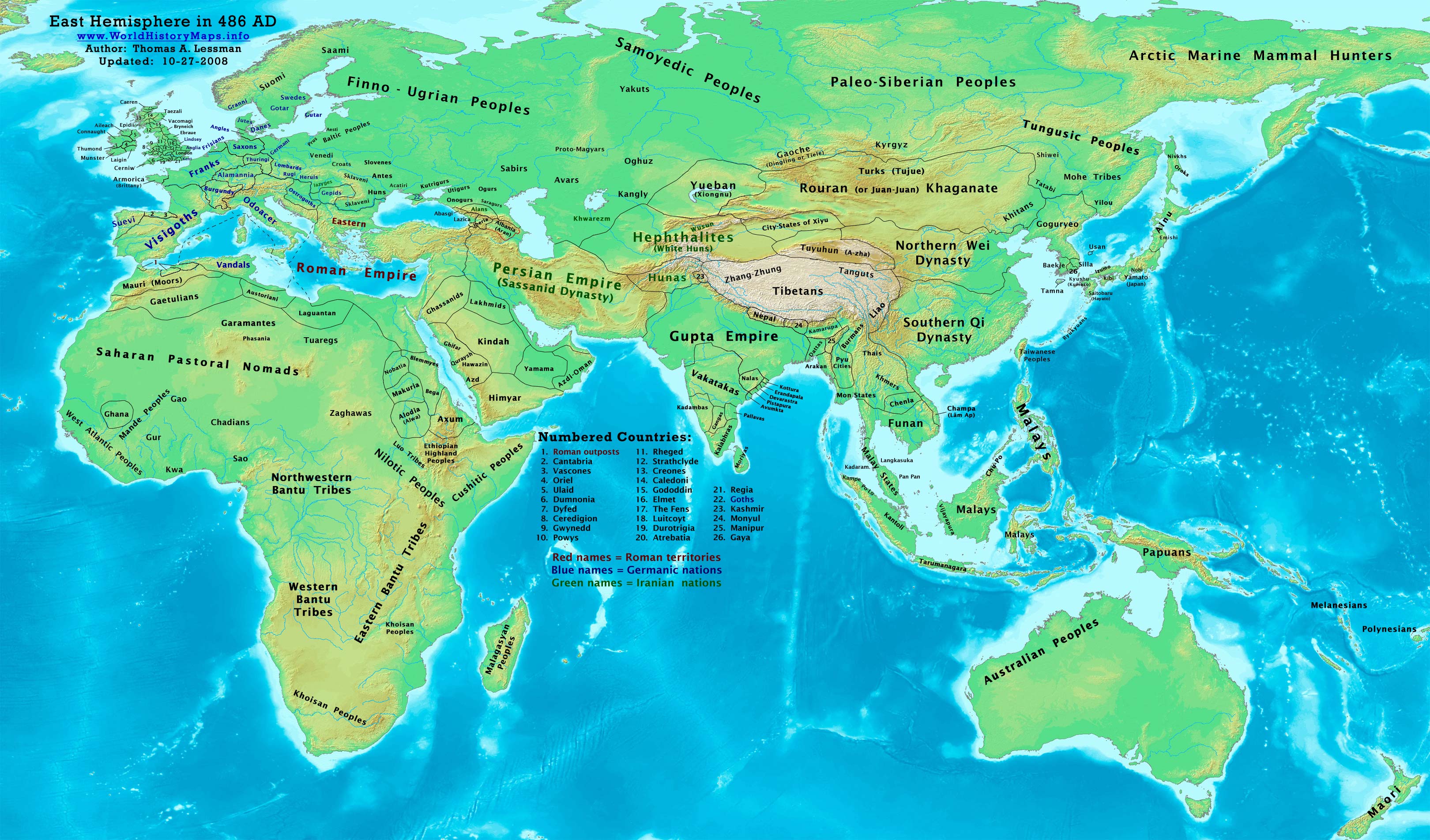
Updated:
Primary Sources for
East-Hem_486ad.jpg:
1. The DK Atlas of World History, 2000
edition. (See specific references below)
2. User:Javierfv1212.
Map of the The_world_in_500_CE.PNG. Available on Wikipedia.
I -
African information:
* African Tribal locations are derived from:
1. The DK Atlas of World History. Map of “Development of Complex
Societies in Africa”. Pg 160.
(Bantus, Berbers, Chadians,
Cushites, Garamantes, Gur, Khoisans, Mandes,
II -
Asian information:
* Greater
India (Including modern Bangladesh, India, and
Pakistan):
* Korean & Manchurian information:
1.
Park
Hyeon. Map of History_of_Korea_300_BC.png. Available on Wikipedia.
*
1.
David
Nash Ford. Early British Kingdoms. Map of
Britain in
475 AD.
* European borders are primarily derived from:
1.
Euratlas.
Periodical
Historical Atlas of Europe. Map of Europe in
500 AD.
IV - Australia, Siberia, & Other Fringe Areas
Note: Fringe information is
derived from comparisons of these sources:
1.
The DK Atlas of World History,
2000 edition. Map of
The World in 500 CE. Pgs 50-51.
2.
User:Javierfv1212.
Map of the The_world_in_500_CE.PNG. Available on Wikipedia.
Note: Much of the information in this map was
cross-checked with Bruce Gordon's Regnal
Chronologies.
|
Continue to:
Medieval Era Maps:
|
||
|
Modern Era Maps:
|
| Homepage | World History Maps | History Timelines | Sources |
| TAL’s History Links |
| The Neighborhood Watch Watch (Thomas’
Blog) |